
I just can’t stop looking at this fun map…
An assemblage of thoughts, actions, ideas and experiences – add to it!
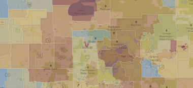
This site visualizes income data per neighborhood. Very interesting.
Yet another fascinating map showing our moving habits. I could be entertained for hours, I’m quite sure.
On the interactive site they also have the median incomes and the direction of where the people are moving (when more than 10 moves are documented from/to a county).
I’ll credit my friend Tony for alerting me to this great find.
 residents")
The moving trends of Cook County (Chicago) residents
One of the coolest mapping sites I’ve seen yet – Radical Cartography sure gets me thinking.
(Image of the Mississippi River found below was found: Yummy>Atlases>Mississippi Meanders – compiled by the Army Corps of Engineers)

Alluvial Valley of the Lower Mississippi River
Beautiful maps put together by many.
See their Flickr site with more cities….

New York City Geotagged
Ever really wanted to know what DC looks like? This map tells one story, and I love its graphic quality. Its also interesting being made up of a combination of tourist and local photographs.
From that site I found an interesting article about downtown Silver Spring (my home for 4 months) and its “no photographs allowed” policy.

DC map

Motion Mapping of bus route
Metro Line
These are a few line maps in a series of experiments I’ve conducted. It’s a visual representation of my body’s movement – dictated in a single line.
It’s something to pass the time, and patterns are fun to analyze. This particular bus route is completely straight, but it doesnt appear that way! While drawing I don’t look at the drawing, and I make sure to lock my wrist and my elbow. One fellow passenger thought I was a transportation analyst or a reporter. I suppose I could be!
. . . . . . . . . . . . . . . . . . . . . . . . .
In response to Daniel’s comment > The original concept or driver was the fact that I was spending so much time riding public transportation and feeling rather unproductive. On one such ride, I was trying to write, and, like all experiences writing in moving vehicles, it was all over the place and not legible, so I decided to just play into it. Locking my elbow and wrist as I sat, letting the motion of the bus or metro guide my pen, looking away and out the window as normal, not focusing on the drawing as it was produced. I learned to keep a certain amount of looseness in my hand to let the pen go where the road or the tracks led the bus or train car. I wanted to look for patterns and trends, and some you could see, but there are so many factors, even when I rode the same routes at nearly the same time, so many traffic and people conditions existed. It was really great seeing the differences between cities (DC, NYC, SF, Bar Harbor, ME) and the BART vs. CAL train vs. the Subway… I’ll post these examples soon.
In essence, I like lines. And there’s something about letting yourself go to the motion, instead of fighting it. It also made me more aware of the motion, and how much we move when we dont realize. Too bad I couldnt figure out a way to do this while biking…but I think I would need a bit more of a complex contraption…


